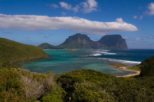
Lord Howe Island
 Unofficial but regularly-flown flag of Lord Howe Island |
|
 |
|
| Geography | |
|---|---|
| Location | Lord Howe Island Group |
| Major islands | Lord Howe Island, Admiralty Islands, Mutton Bird Islands and Balls Pyramid |
| Area | 56 km2 (21.6 sq mi) |
| Highest elevation | 875 m (2,871 ft) |
| Highest point | Mount Gower |
| Country | |
|
Australia
|
|
| Administrative Division | Unincorporated area of New South Wales Self-governed by Lord Howe Island Board[1] Part of the electoral district of Port Macquarie[2] Part of the Division of Sydney[3] |
| Largest city | Lord Howe Island (pop. 347[4]) |
| Demographics | |
| Population | 347 permanent residents.[4] Tourists are restricted to 400 at any one time.[5] |
| Density | 23.97 /km2 (62.08 /sq mi) |
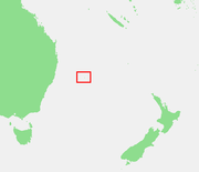
Lord Howe Island (pronounced /ˈhaʊ/, or /ˈhæɔ/ in Australian English phonology) is a small island in the Tasman Sea 600 kilometres (370 mi) east of the Australian mainland. The Lord Howe Island Group, including nearby Balls Pyramid, is administered by the Lord Howe Island Board,[6] and is part of the Mid-North Coast Statistical Division of New South Wales, Australia. It is not considered a Local Government Area and is therefore unincorporated (as is the Unincorporated Far West Region), but is self-governed by the Lord Howe Island Board.[1] The Lord Howe Island group was inscribed as a World Heritage Site in 1982 in recognition of its unique beauty and biodiversity.[7] The NSW Lord Howe Island Marine Park and Commonwealth Lord Howe Island Marine Park (commonwealth waters) protect the waters surrounding the island group.[8]
The island's standard time zone is UTC+10:30. During daylight saving time this shifts forward by only half an hour to UTC+11.[9]
Contents |
History
Lord Howe Island was discovered on 17 February 1788, by HMS Supply, commanded by Lieutenant Henry Lidgbird Ball, RN, who was on his way from Botany Bay to Norfolk Island with convicts to start a penal settlement there. On his return journey on 13 March 1788, he sent a party ashore on the island. It was uninhabited, and it seems that it had not been known to any of the Polynesian peoples of the South Pacific. Whilst Mount Lidgbird on the island and the nearby Balls Pyramid are named after Ball, the island itself was named after Richard Howe, 1st Earl Howe, who was First Lord of the Admiralty.[10]
Many government ships sailing between New South Wales and Norfolk Island stopped at the island, as did some whaling and trading vessels. Some ships left goats and pigs on the island for food for future visitors though a permanent settlement was not established until 1834 at an area known today as Old Settlement.[10]
Until the construction of Lord Howe Island Airport in 1974, the only way to reach the island was by sea or by flying boat from Rose Bay in Sydney, landing on the lagoon surrounded by the coral reef. In 2002 the Royal Navy Destroyer HMS Nottingham struck Wolf Rock, a reef at Lord Howe Island, and almost sank.[11]
| Lord Howe Island Group* | |
|---|---|
| UNESCO World Heritage Site | |
| State Party | |
| Type | Natural |
| Criteria | vii, x |
| Reference | 186 |
| Region** | Asia-Pacific |
| Inscription history | |
| Inscription | 1982 (6th Session) |
| * Name as inscribed on World Heritage List. ** Region as classified by UNESCO. |
|
Governance
The Lord Howe Island Board is a NSW Statutory Authority established under the Lord Howe Island Act,1953, to administer the island as part of New South Wales, Australia, in the Tasman Sea between Australia and New Zealand. It reports directly to the New South Wales Minister for Climate Change, Environment and Water, and is responsible for the care, control and management of the island. Its duties include the:
- protection of World Heritage values
- control of development
- administration of Crown Land, including the island’s protected area, the Permanent Park Preserve
- provision of community services and infrastructure
- delivery of sustainable tourism
The Board also manages the Kentia Palm Nursery which, with tourism, provide the island's only sources of external income.
The Board comprises seven members, four of whom are elected from the islander community, thus giving the approximately 350 permanent residents a high level of autonomy. The remaining three members are appointed by the Minister to represent the interests of business, tourism and conservation. The full Board meets on the island every three months while the day-to-day affairs of the island are managed by the Board’s administration, with a permanent staff of about 30.[12]
Natural environment
Geology
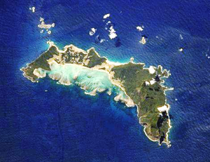
Lord Howe island is roughly crescent-shaped, about 10 kilometres (6.2 mi) long and 2 kilometres (1.2 mi) wide.[13] It is an eroded remnant of a 7 million-year-old shield volcano.[13] The crescent of the island protects a coral reef and lagoon. The Lord Howe seamount chain, defined by coral-capped guyots, extends to the north for 1000 km (600 mi), most likely the result of the Indo-Australian Plate moving northward over a stationary hotspot (see plate tectonics). This chain is one of a number of features found on the plateau known as the Lord Howe Rise, part of the submerged continent of Zealandia.
Mount Lidgbird 777 metres (2,549 ft) and Mount Gower 875 m (2,871 ft) dominate the south end of the island.[14] They are both made of basalt rock, remnants of lava flows that once filled a large volcanic caldera.[14] These lava flows occurred 6.4 million years ago, and were the last volcanic events on the island, which has subsequently eroded to what remains today.[14]
The coral barrier reef, at 31° S, is the most southerly in the world.[14][15]
Balls Pyramid is a rocky islet located 23 km (14 mi) south of Lord Howe Island, and also the remnant of an eroded volcano. It is the tallest volcanic stack in the world, one of many stacks that form islets in the area.[14][15]
Climate
| Climate data for Lord Howe Island | |||||||||||||
|---|---|---|---|---|---|---|---|---|---|---|---|---|---|
| Month | Jan | Feb | Mar | Apr | May | Jun | Jul | Aug | Sep | Oct | Nov | Dec | Year |
| Average high °C (°F) | 25.2 (77.4) |
25.6 (78.1) |
24.7 (76.5) |
23.2 (73.8) |
21.5 (70.7) |
19.9 (67.8) |
18.9 (66) |
18.9 (66) |
19.9 (67.8) |
20.9 (69.6) |
22.1 (71.8) |
23.9 (75) |
22.0 (71.6) |
| Average low °C (°F) | 20.6 (69.1) |
20.9 (69.6) |
19.8 (67.6) |
17.9 (64.2) |
16.5 (61.7) |
14.9 (58.8) |
14.0 (57.2) |
13.4 (56.1) |
14.6 (58.3) |
15.7 (60.3) |
17.2 (63) |
19.0 (66.2) |
17.0 (62.6) |
| Precipitation mm (inches) | 119.9 (4.72) |
114.3 (4.5) |
132.0 (5.197) |
113.1 (4.453) |
152.3 (5.996) |
177.1 (6.972) |
143.5 (5.65) |
103.2 (4.063) |
108.9 (4.287) |
111.2 (4.378) |
112.6 (4.433) |
101.4 (3.992) |
1,487.1 (58.547) |
| Source: [16] | |||||||||||||
Flora
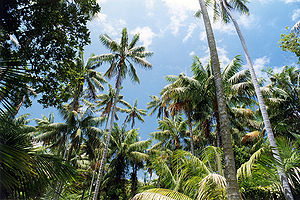
Lord Howe island is a distinct terrestrial ecoregion, known as the Lord Howe Island subtropical forests.[13] It is part of the Australasia ecozone, and shares many biotic affinities with Australia, New Guinea, and New Caledonia. Lord Howe Island was never part of a continent, and all of its flora and fauna colonized the island from across the sea. Almost half of the island's native plants are endemic. One of the best known is Howea, an endemic genus of palms (Arecaceae) that are commonly known as kentia palms and make handsome houseplants. Several million are exported annually providing the only major industry on the island apart from tourism.
Another endemic feature of the island are the glowing mushrooms, which can be seen after heavy rain, including species such as Mycena chlorophanos and Omphalotus nidiformis. Found in the palm forests, they continue glowing for a number of days after being picked. The glow is bright enough that it can be used for reading at night.[15]
Fauna
Birds
Lord Howe Island, with its adjacent islets, is an important breeding site for several kinds of seabirds. They include the Providence Petrel, for which the island was its only breeding location for many years after the breeding colony on Norfolk Island was exterminated in the late 19th century.[17] The Kermadec Petrel was discovered as a breeder on Mount Gower in 1914 by Roy Bell while collecting specimens for Gregory Mathews.[18] The Black-winged Petrel was not confirmed as a breeder until 1971; it has been able to increase its numbers following the elimination of feral cats from the island.[19] The Flesh-footed Shearwater breeds in very large numbers in summer; its chicks were heavily harvested by the islanders for food.[20] Wedge-tailed and Little Shearwaters also breed on the island. Breeding White-bellied Storm-petrels were another discovery by Roy Bell.[21] Masked Boobies are the largest seabirds breeding on Lord Howe.[22] Red-tailed Tropicbirds breed on the island's cliffs in large numbers.[23] The Sooty Tern is the most numerous of the island’s breeding seabirds; its eggs were formerly harvested for food. Common and Black Noddies build nests in trees and bushes, while the White Tern simply lays its single egg precariously in a slight depression on a tree branch,[24] and the Grey Ternlet lays its egg in a cliff hollow.[25]
Species of landbirds that breed on the island group include an iconic endemic rail, the Lord Howe Woodhen, and three endemic passerine subspecies of the Golden Whistler, Silvereye and Currawong.[26]
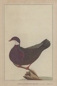
Several endemic bird species and subspecies have become extinct since the arrival of humans on the island. The first round of extinctions included the Lord Howe Swamphen or White Gallinule, White-throated Pigeon, Red-crowned Parakeet and the Tasman Booby, which were eliminated by visitors and settlers during the nineteenth century either from overhunting for food or persecution for raiding crops.[26]
The accidental introduction of the Black Rat in the 1918 shipwreck of the SS Makambo triggered a second wave of extinctions, including the Vinous-tinted Thrush, Robust White-eye, Lord Howe Starling, Lord Howe Fantail and the Lord Howe Gerygone. The Lord Howe Boobook may have become extinct through predation by, or competition with, the Tasmanian Masked Owls introduced in the 1920s in a failed attempt to control the rat population.[26]
Other animals
Only one native mammal remains on the islands, the Large Forest Bat (Eptesicus sagittula). The endemic bat species Nyctophilus howensis is known only from a skull and is now presumed extinct. The cause of its extinction may also have been predation by Masked Owls.
Two terrestrial reptiles are native to the island group: a skink (Leiolopisma lichenigera)) and a gecko (Phyllodactylus guentheri). Both are rare on the main island but more common on smaller islands offshore. The Garden Skink (Lampropholis delicata) and the Bleating Tree Frog (Litoria dentata) have been accidentally introduced from the Australian mainland in recent years.
The Lord Howe Island stick insect (Dryococelus australis) disappeared from the main island soon after the introduction of rats. In 2001 a tiny population was discovered in a single (Melaleuca howeana) shrub on the slopes of Balls Pyramid.[27]
Another endemic invertebrate, the Lord Howe Placostylus, has also been affected by the introduction of rats. Once common, the species is now endangered and a captive breeding program is under way to save the snail from extinction.
Australian underwater photographer Neville Coleman has photographed various nudibranches at Lord Howe Island.[28]
Over 400 fish species are found in the waters around Lord Howe including 9 endemic to the region. Over 80 species of coral occur in the reefs surrounding the islands.
Threats and conservation
About 10 percent of Lord Howe Island's forests have been cleared for agriculture, and another 20 percent has been disturbed by domestic cattle and feral sheep, goats, and pigs. Despite a large number of introduced species that harm Lord Howe's native flora and fauna, feral pigs have recently been eliminated from the island, the goat population has been reduced, and there are ongoing efforts to control rats, mice, and introduced plants. A recovery program has restored the Lord Howe Woodhen numbers from only 20 in 1970 to approximately 200, not that distant from carrying capacity[29]. Stray dogs are also a threat as they could harm the native wood hen and other birds.
According to an analysis by Tim Flannery, the ecosystem of Lord Howe Island is threatened by climate change and global warming, with the reefs at risk from rises in water temperature.[30] The Great Barrier Reef is specifically identified as being at risk to the effects of global warming on Australia, and the same analysis applies to the reefs of Lord Howe Island.[31] Cool climate flora and fauna would be at risk from rises in temperature, as those on or near the top of Mount Gower cannot migrate higher to stay within their preferred temperature range. Many bird species are also under constant threat in the island as a result of rats. The island's bird population has been significantly reduced by them and some species have already been wiped out because of rats introduced by the grounding of the SS Makambo.
On July 15, 2009, a Tsunami warning was issued to Lord Howe Island after an Earthquake measuring 7.9 hit New Zealand.
See also
- Jim Lacey - Former administrator of Lord Howe Island beginning in 1983.[32]
- Lord Howe Island Airport
References
Notes
- ↑ 1.0 1.1 Regional Statistics - New South Wales, Australian Bureau of Statistics, 2004. Retrieved on 2009-04-19.
- ↑ PORT MACQUARIE, New South Wales Electoral Commission, 2008. Retrieved on 2009-04-19.
- ↑ http://www.aec.gov.au/pdf/profiles/s/sydney.pdf "COMMONWEALTH ELECTORAL DIVISION OF SYDNEY", Australian Electoral Commission, 2006. Retrieved on 2009-04-19.
- ↑ 4.0 4.1 2006 Census QuickStats- Lord Howe Island (Statistical Local Area), Australian Bureau of Statistics, 2007-10-25. Retrieved on 2009-04-20.
- ↑ Lord Howe Island community thriving online, .au Community Domains Trust, 2009-02-11. Retrieved on 2009-04-20.
- ↑ Lord Howe Island Group: more information, Australian Government: Department of the Environment, Water, Heritage and the Arts, 2008. Retrieved on 2009-04-20.
- ↑ Lord Howe Island Group, UNESCO World Heritage Centre, 2009. Retrieved on 2009-04-20.
- ↑ Lord Howe Island Marine Park (Commonwealth Waters), Australian Government: Department of the Environment, Water, Heritage and the Arts, 2008. Retrieved on 2009-04-20.
- ↑ Information for Visitors, Lord Howe Island Tourism Association. Retrieved on 2009-04-20.
- ↑ 10.0 10.1 Hutton (1998).
- ↑ "Battle to save stricken warship". BBC News. 2002-07-07. http://news.bbc.co.uk/2/hi/asia-pacific/2112710.stm. Retrieved 2007-03-08.
- ↑ "Administration", in Lord Howe Island: 1788-1988.
- ↑ 13.0 13.1 13.2 Lord Howe Island subtropical forests (AA0109), World Wildlife Fund, 2001. Retrieved on 2009-04-20
- ↑ 14.0 14.1 14.2 14.3 14.4 Geography and Geology, Lord Howe Island Tourism Association. Retrieved on 2009-04-20.
- ↑ 15.0 15.1 15.2 Barton, Greg (2007). "Ten Ridiculously Amazing Things To Do On Lord Howe Island", Australian Traveller. Retrieved on 2009-04-20.
- ↑ "Summary statistics Lord Howe Island Aero". Australian Bureau of Meteorology. http://www.bom.gov.au/climate/averages/tables/cw_200839.shtml. Retrieved 2009-03-23.
- ↑ Hutton (1990), p.68.
- ↑ Hutton (1990), p.70.
- ↑ Hutton (1990), p.72.
- ↑ Hutton (1990), p.74.
- ↑ Hutton (1990), p.80.
- ↑ Hutton (1990), p.82.
- ↑ Hutton (1990), p.84.
- ↑ Hutton (1990), p.92.
- ↑ Hutton (1990), pp.92-94.
- ↑ 26.0 26.1 26.2 Hutton (1990).
- ↑ Dryococelus australis in Species Profile and Threats Database, Australian Government: Department of the Environment, Water, Heritage and the Arts, 2009. Retrieved on 2009-04-21.
- ↑ Coleman (2001).
- ↑ "Lord Howe Woodhen Gallirallus sylvestris". BirdLife International. http://www.birdlife.org/datazone/search/species_search.html?action=SpcHTMDetails.asp&sid=2850&m=0. Retrieved 12 June 2009.
- ↑ Flannery (2006).
- ↑ Jones, R.N. (2004) Managing Climate Change Risks, in Agrawala, S. and Corfee-Morlot, J. (eds.), The Benefits of Climate Change Policies: Analytical and Framework Issues, OECD, Paris, 249–298, cited in the CSIRO's Climate Change Impacts on Australia and the Benefits of Early Action to Reduce Global Greenhouse Gas Emissions" [1]
- ↑ North, Bill (2008-02-18). "Death of zoo pioneer". Dubbo Daily Liberal. http://dubbo.yourguide.com.au/news/local/general/death-of-zoo-pioneer/1184921.html. Retrieved 2008-02-21.
Sources
- Coleman, Neville. (2001). 1001 Nudibranchs - Catalogue of Indo-Pacific Sea Slugs. Author: Springwood. ISBN 0947325255
- Flannery, Tim. (2006). The Weather Makers - The History and Future Impact of Climate Change. Allen Lane: UK. ISBN 978-0-713-99921-1
- Hutton, Ian (1990). Birds of Lord Howe Island - Past and Present. Author. ISBN 0-646-02638-0.
- Hutton, Ian (1998). The Australian Geographic Book of Lord Howe Island. Australian Geographic. ISBN 1-876276-27-4.
- Lord Howe Island: 1788-1988. From Antipodean Isolation to World Heritage. A Bicentennial Publication. National Library of Australia. ISBN 0 7316 3090 4 [2]
External links
- Lord Howe Island Tourism Association web site (Regarded by local residents as the "Official" home page)
- World heritage listing for Lord Howe Island
- Lord Howe Island subtropical forests (World Wide Fund for Nature)
- Rodent eradication on Lord Howe Island (Foundation for National Parks & Wildlife)
- Jane's Lord Howe Island Page
- Chart of Lord Howe Island by J. Stockdale from 1789, at the National Maritime Museum
- Wikiscuba - Lord Howe Island
- Maps
- Lamprima insularis - Lord Howe Island endemic species
- Lord Howe Island Board
- Lord Howe Island Act, 1953
|
||||||||||||||||||||||||||||||||